The Geophysical Instrument Service
Horng-Yuan Yen and Hsuan-Yu Kuo
National Central University
doi: 10.30067/TECNL.202206_1(1).0007
(中文版)
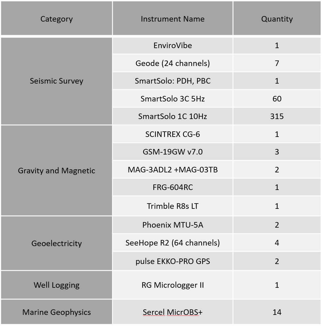
The Geophysical Instrument Service center was established in 2011 under the framework of the Taiwan Earthquake Research Center and using the "Seismic Instrument Service Center" as the blueprint. The Department of Earth Sciences of the Central University is in charge of the center, which was established to develop the instruments required for the implementation of geophysical methods, including seismic, gravity, magnetic, and geoelectric surveys, geothermal processes, marine geophysics, and well logging, as well as the provision of data processing service platforms. Combined with the Seismic Instrument Service Center, this plan establishes and expands the instrument service structure, provides basic geophysical instruments, and serves the geoscience community. Many types of instruments have been deployed, such as ocean bottom seismometers, well logging equipment, magneto-telluric equipment, ground-penetrating radar systems, electrical resistivity equipment, gravimeters and magnetometers, vibrator vehicles, and seismic recording equipment (Table 1). For detailed information, please refer to the TEC website.

Table 1、Equipments of the geophysical instrument service platform.
To build an instrument sharing system, it is necessary to set up a management agency to effectively integrate and manage instrument resources so that the maximum scientific value can be extracted. In addition to instrument technicians, the Instrument Center also has a committee that is responsible for coordinating the demand for new instruments, determining instrument usage rules, and reviewing instrument specifications. In addition to providing supervision, management, and the reviewing of the annual use plan, the Committee needs to have close contact and cooperation with the research projects of the Taiwan Earthquake Research Center. The submission of observational data in a unified format within a certain period of time and availability to other researchers for shared use is another important consideration.
This project also designs internship courses for various geophysical instruments and provides applications for geophysics-related courses in universities. Through the practical operation of geophysical instruments, it helps to increase student interest in learning about the detection methods of instruments. Please visit the TEC website to apply: https://docs.google.com/forms/d/e/1FAIpQLSc1VLaGT6Q9QSr38HyNWErTRZUHuYZJJxk7A2I9J0FpAzrHMQ/viewform
Top
|


