TEC通訊 |
上一頁 |
首頁 |
下一頁


|
||
The Taiwan Earthquake Research Data Center (TECDC)Wen-Tzong Liang Institute of Earth Sciences, Academia Sinica, Taiwandoi: 10.30067/TECNL.202206_1(1).0003
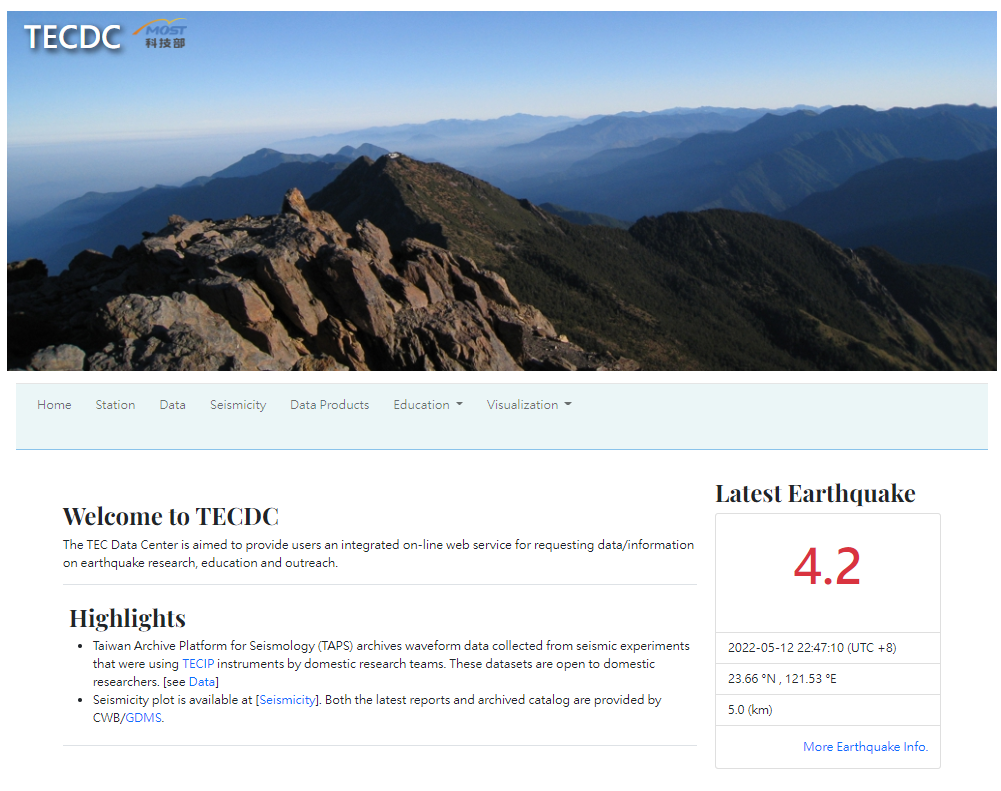
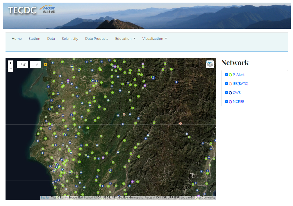
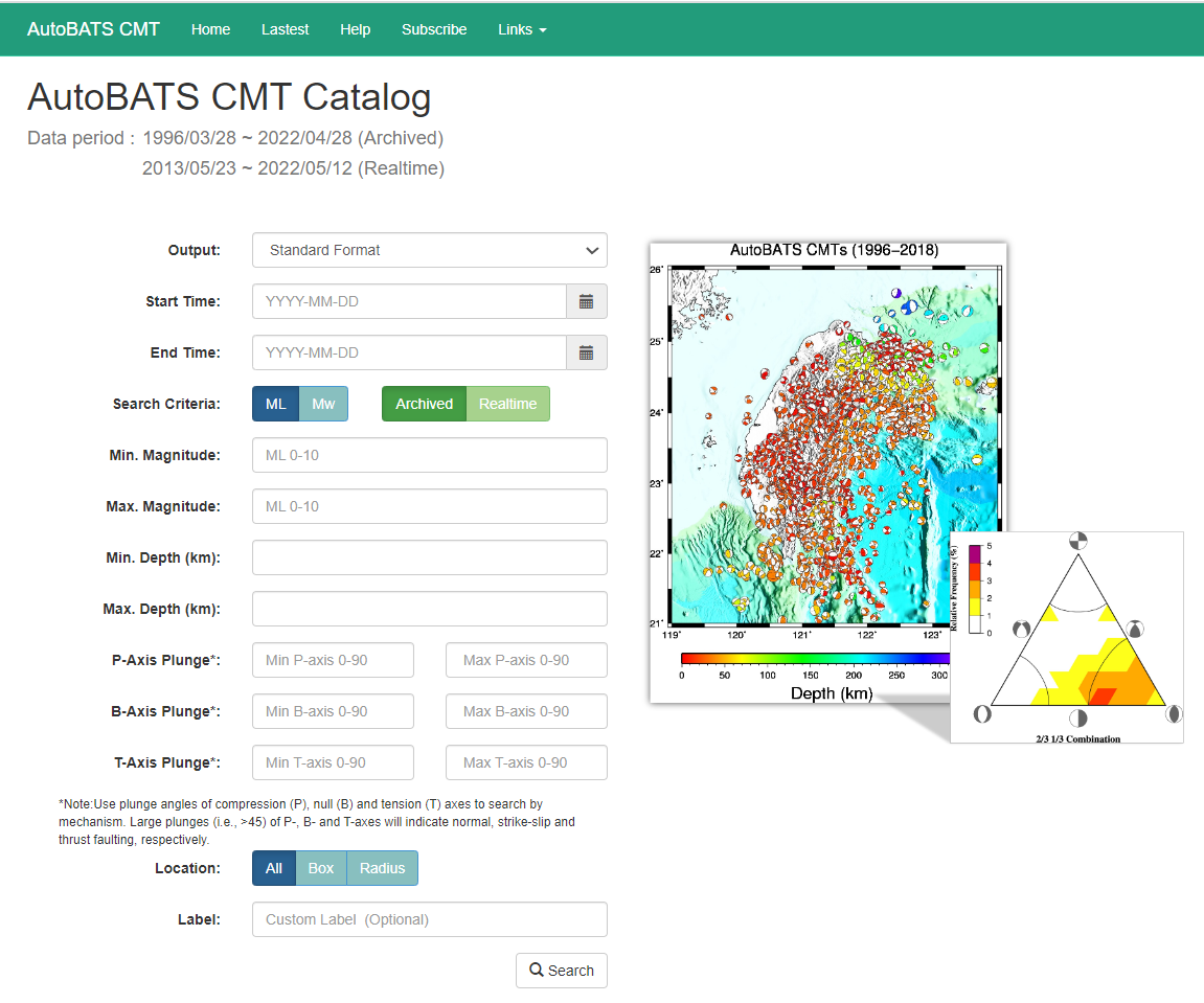
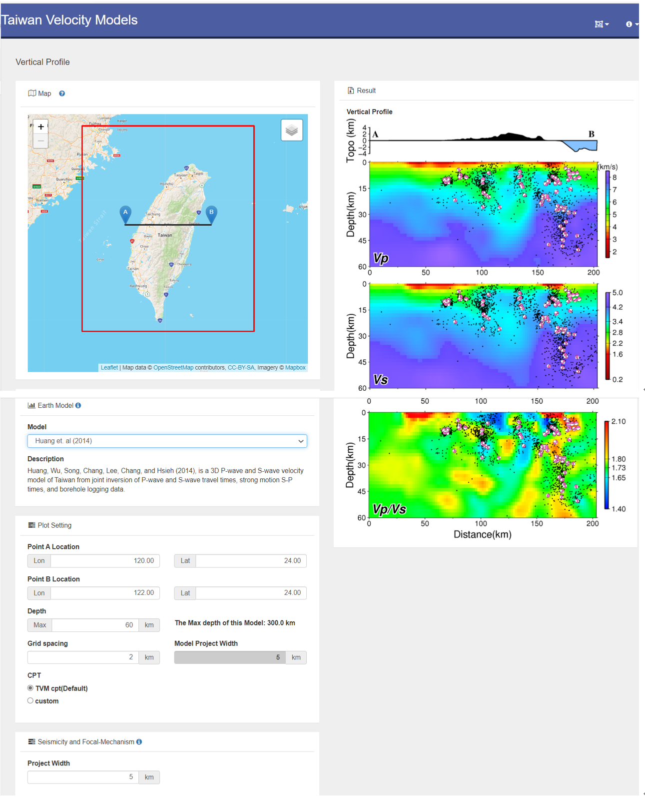
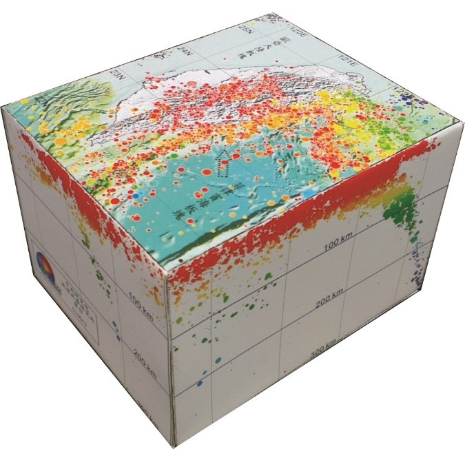
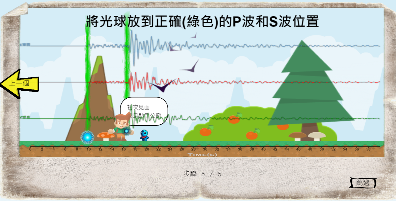
ABSTRACT The Taiwan Earthquake Research Data Center (TECDC) is primarily sponsored by the Ministry of Science and Technology (MOST) and its aim is to integrate all available seismological data to serve the entire Taiwan research community. The TECDC is dedicated to the development of web services for the data sharing of both existing, backbone seismic networks and research-based temporary seismic arrays, and also for the demonstration of research outcomes and data products derived from domestic scientific outputs. We have also designed various online activities to promote seismological education and outreach. The official web portal of the TECDC is accessible at https://tecdc.earth.sinica.edu.tw (Fig. 1). Figure 1. The web portal of the Taiwan Earthquake Research Data Center (TECDC) at https://tecdc.earth.sinica.edu.tw. Data IntegrationTo meet the demands of modern observational seismology developed in Taiwan, we have taken advantage of new web technologies to establish a web service system for the Broadband Array in Taiwan for Seismology (BATS). BATS is operated by the Institute of Earth Sciences, Academia Sinica and plays the role of the backbone seismic network in the Taiwan region. All BATS stations are equipped with state-of-the-art seismometers and the high-quality data collected have been open to the public since 1996 (Institute of Earth Sciences, Academia Sinica, Taiwan, 1996). The links of the web service system are available at http://bats.earth.sinica.edu.tw . According to the Taiwan Earthquake Research Center (TEC) data delivery policy, Principal Investigators (PIs) who have utilized TEC equipment have to deliver their collected data and associated metadata to the TECDC. The delivered dataset will be archived at the TECDC and be accessible for all Taiwan-based researchers for a two year period after the seismic experiment. To integrate all the archived datasets, we train each research group on how to construct a standard database in which both daily waveforms and associated metadata are organized in an appropriate manner. We also constructed the Taiwan Archive Platform for Seismology (TAPS) web services to enable the sharing of all experimental data under the TEC data policy. Users are able to request any data collected from the archived seismic experiments using just one platform, simply by registering an account. The web portal of TAPS is ready at https://taps.earth.sinica.edu.tw. We have gained a lot of experience at creating seismic data web service systems over the past decade. The Taiwan Central Weather Bureau (CWB) intends to open up their data, which has been collected by various seismic networks and geophysical networks, through a collaboration between the CWB, IES and TEC beginning in 2020. We have successfully developed the Taiwan Seismological and Geophysical Data Management System (GDMS) to share these invaluable datasets with the world in 2022. The official website of the Taiwan GDMS is accessible at https://gdmsn.cwb.gov.tw. Figure 2 shows the distribution of seismic stations operated by various organizations in Southwestern Taiwan. This online station map can be found at the TECDC. Figure 2. Distribution of seismic stations operated by various institutions in SW Taiwan. Real-time Seismology The TECDC has been collaborating with several research groups to practically develop Taiwan real-time seismology. For instance, the real-time intensity map, animation and event-based database of the P-Alert Strong Motion Network (Wu et al., 2013) (https://palert.earth.sinica.edu.tw). With regard to the near real-time source inversion of the BATS waveform data, we have not only collaborated with Dr. Shiann-Jong Lee to develop the Real-time Moment Tensor Monitoring System (RMT, Lee et al., 2013; http://rmt.earth.sinica.edu.tw) but have also automated the previous BATS CMT source inversion scheme (AutoBATS solution, Jian et al., 2018; https://tecdc.earth.sinica.edu.tw/FM/AutoBATS/) (Fig. 3). These solutions will be published in the Taiwan Earthquake Science Information System (TESIS, https://tesis.earth.sinica.edu.tw) within five minutes after the occurrence of an earthquake and can be disseminated to subscribers after manual verification via e-mail. Furthermore, we performed the regional W-Phase source inversion technique (Kanamori & Rivera, 2008) to obtain a robust estimate of the magnitude and source mechanism of large earthquakes that occurred in the Taiwan area. To make sure the point source assumption was still valid, we exchanged real-time waveform data with neighboring countries to form a large aperture seismic network on a regional scale. The near real-time regional W-Phase solutions are presented at https://tecdc.earth.sinica.edu.tw/FM/WP/. Figure 3. The homepage of the AutoBATS MT solution database. Data Product Depository Referring to the IRIS Earth Model Collaboration (EMC; IRISDMC, 2011) product, we have constructed an online web service system for data product management and model previewing as the outcome of the Taiwan Velocity Model (TVM) project in order to provide the research community with access to various Taiwan 3D velocity and attenuation models. This is the first scientific outcome that has been hosted by the TECDC. This web service has archived 3D models that were published in the past three decades and the most updated model (Chen et al., 2019) will be accommodated within a short time. Users are able to select a model and mark a section on the map to plot a 2D profile of regional velocity or attenuation structure, which can be superimposed with seismicity and focal mechanisms. The TVM web service (Fig. 4) is accessible athttps://tecdc.earth.sinica.edu.tw/TWtomo/. Figure 4. Web service of the Taiwan Velocity Model. In addition, we have designed interfaces for the visualization of Taiwan seismicity in several different ways. The Taiwan Seismicity Map is provided for the rapid assessment of the spatiotemporal distribution of aftershocks and historic earthquake sequences. On the other hand, the animation and 3D paper model are mainly for educational purposes. All these web services are available in the Seismicity function of the TECDC. Education and outreach The TECDC has developed an abundance of classroom activities for promoting self-learning ability in earthquake science (Liang et al., 2016). Users are able to use this facility to independently determine the epicenter and magnitude of earthquakes. We have provided a design for instructors and students to build an inertial seismometer with low-cost materials (TEC-100), which demonstrates the basic physics behind a modern seismometer. We have also designed a handy paper model that shows the 3D distribution of the hypocenter that occurred in the Taiwan region (Fig. 5) to provide a better understanding of the tectonic setting of Taiwan through earthquakes. A recent development of the web-based role-playing game (RPG) about earthquake locations was published this June (Chiu et al., 2022), and we have added many additional game elements to make it more attractive (Fig. 6). Players are able to determine the epicenter easily by selecting the P and S waves for each seismic station. With the knowledge gained in the game, they will be equipped with the power to find the hypocenter, destroy the monster and save the world.
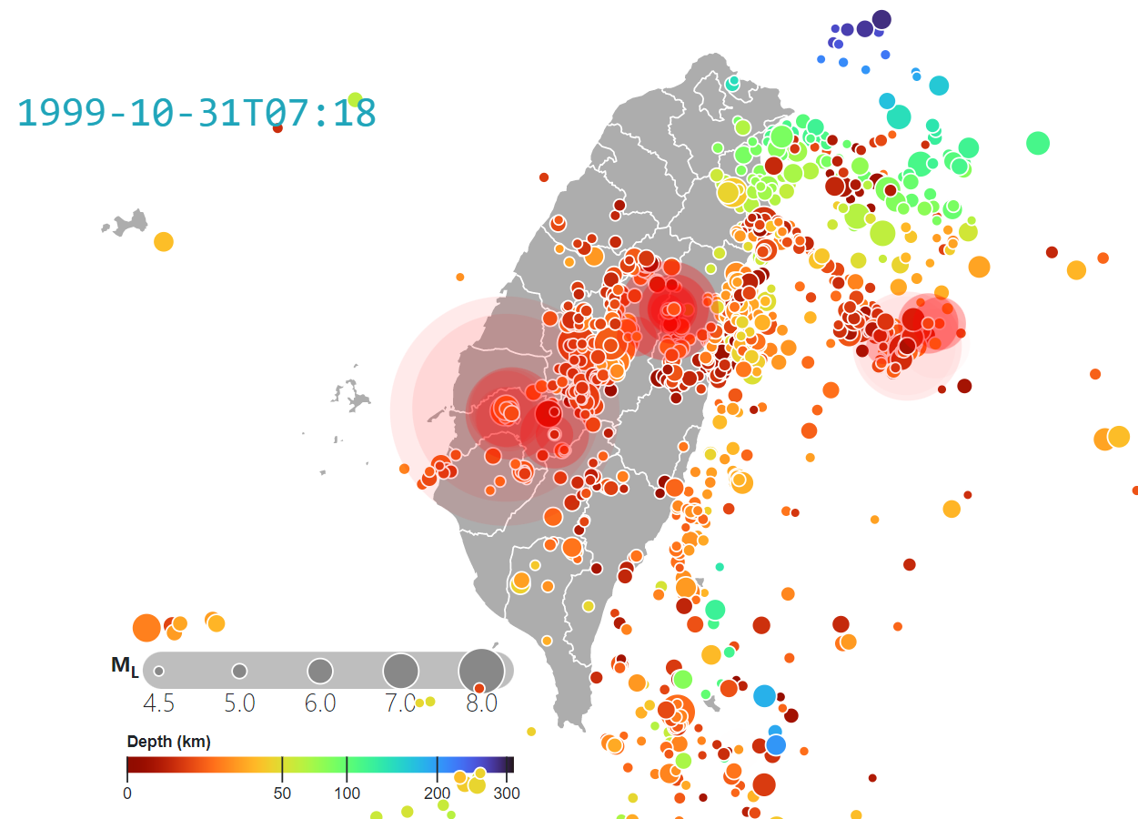
Visualization Services To help PIs plan the deployment of seismic arrays, we have provided an on-line converter that converts text content into a keyhole markup language (KML) file, which can be used to superimpose the station information onto Google Earth, a powerful web-GIS platform supported by Google. Another service plots the instrument response, in which both the amplitude and phase spectra are presented from the pole-and-zero values input by users. This is essential for understanding the characteristics of the seismograph typically used in practice. Figure 7 shows a snapshot of an online Taiwan seismicity animation accumulated from earthquake data from 1991-01-01 to 1999-10-31 with ML > 4.5. Both the progress and the play speed can be adjusted by users. Figure 7. A snapshot of a Taiwan seismicity animation accumulated for earthquakes with ML > 4.5 from 1991 to 1999-10-31. Concluding Remarks The main mission of the TECDC is to support the development of infrastructure, which aims to open up seismological data to researchers. We have continuously accumulated experience over the past two decades in modern seismic data technology. In recent years, we have integrated existing seismic waveform databases and collaborated with various research institutions to develop web service systems for data sharing in a standard format. To broaden the possible applications of achieved scientific outcomes, we are developing a data products depository for the scientific results derived by Taiwanese geoscientists. We will definitely continue this work, hoping to increasingly contribute to the entire research community. ReferencesCentral Weather Bureau (CWB, Taiwan) (2012). Central Weather Bureau Seismographic Network [Data set]. International Federation of Digital Seismograph Networks. https://doi.org/10.7914/SN/T5 Chen, C.-T., and S.-J. Lee (2019). Verification of the 3D velocity models in Taiwan through forward waveform simulations. 2019 Taiwan Geosciences Assembly (2019 TGA), GS-S1-017. Chiu, H.-T., C.-F. Lee, W.-H. Lee, C.-H. Lo, W.-T. Liang, C.-H. Chiu, and K. H. Chen (2022). A web-based role play game for learning earthquake location. 2022 Taiwan Geosciences Assembly (2022 TGA), EE02-003. Institute of Earth Sciences, Academia Sinica, Taiwan (1996). Broadband Array in Taiwan for Seismology. Institute of Earth Sciences, Academia Sinica, Taiwan. Other/Seismic Network. https://doi.org/10.7914/SN/TW IRIS DMC (2011). Data Services Products: EMC, A repository of Earth models. https://doi.org/10.17611/DP/EMC.1 Jian, P.-R., T.-L. Tseng, W.-T. Liang, and P.-H. Huang (2018). A New Automatic Full‐Waveform Regional Moment Tensor Inversion Algorithm and Its Applications in the Taiwan Area. Bulletin of the Seismological Society of America, 108(2), 573–587. https://doi.org/10.1785/0120170231 Kanamori, H., and L. Rivera (2008). Source inversion of W phase: speeding up seismic tsunami warning. Geophysical Journal International, 175(1), 222–238. https://doi.org/10.1111/j.1365-246x.2008.03887.x Lee, S.-J., W.-T. Liang, H.-W. Cheng, F.-S. Tu, K.-F. Ma, H. Tsuruoka, H. Kawakatsu, B.-S. Huang, and C.-C. Liu (2013). Towards real-time regional earthquake simulation I: real-time moment tensor monitoring (RMT) for regional events in Taiwan. Geophysical Journal International, 196(1), 432–446. https://doi.org/10.1093/gji/ggt371 Liang, W.-T., K. H. Chen, Y.-F. Wu, E. Yen, and C.-Y. Chang (2015). Earthquake School in the Cloud: Citizen Seismologists in Taiwan. Seismological Research Letters, 87(1), 177–185. https://doi.org/10.1785/0220150061 Wu, Y.-M., D.-Y. Chen, T.-L. Lin, C.-Y. Hsieh, T.-L. Chin, W.-Y. Chang, W.-S. Li, and S.-H. Ker (2013). A High-Density Seismic Network for Earthquake Early Warning in Taiwan Based on Low Cost Sensors. Seismological Research Letters, 84(6), 1048–1054. https://doi.org/10.1785/0220130085 | ||
