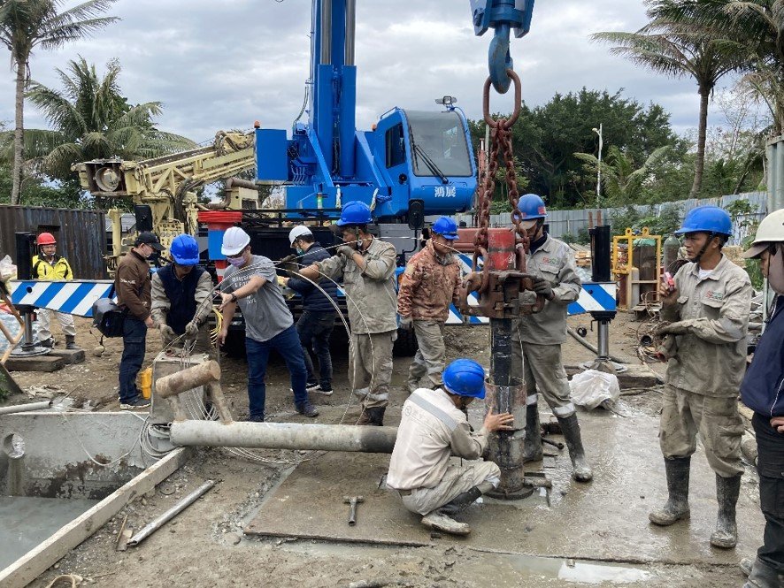
The Institute of Earth Sciences of Academia Sinica and National Central University’s Earthquake Disaster Chain Risk Assessment and Management Research Center jointly carried out the ” Cross-Milun Fault Downhole Optical Fiber Seismic Research ” , and set up two underground seismic observation stations in Qixingtan, Hualien, and introduced optical fiber seismic observation technology , is the world’s first cross-fault optical fiber seismic observation research, opening the “light” generation of seismic observation.
The Hualien earthquake in 2018 caused huge casualties. Among them, the Milun Fault, which caused serious disasters, requires more attention because the seismic activity cycle is less than a century. Earthquake disaster risk assessment is an item that cannot be ignored in modern urban development planning, and it is even more necessary to collect complete earthquake background information before conducting earthquake disaster risk assessment. In order to understand the Hualien earthquake and its future potential, Professor Kuo-Fong Ma, with the support of the key projects of the Academia Sinica and the Ministry of Education’s Higher Education Deep Cultivation Project, cooperated with the Institute of Earth Sciences of the Academia Sinica and the earthquake disaster chain risk assessment and management of Central University The research center, Donghua University School of Environment and other academic institutions will launch the Milun fault Drilling and All-inclusive Sensing project (MiDAS) in 2020.
The site of the seismic observation station is located on the northwestern edge of the Milun Terrace, near the coast of Qixingtan. By drilling two dual observation wells penetrating through the Milun fault, an underground seismic observation station is set up. Introducing optical fiber seismic observation technology, and referring to the research experience of Chelongpu Fault Drilling (TCDP), the new generation of seismic optical fiber combines traditional downhole seismographs with water and gas monitoring in fault zones to establish a cross-fault seismic observation system. The data of the surrounding seismogenic structure and fault dynamics are provided, which will help to explore the dislocation and fault system mechanism of the Milun Fault, and propose disaster prevention countermeasures.
After the Chi-Chi Earthquake at the end of the 20th century, the Taiwan Chelungpu-fault Drilling Project (TCDP) of the Ministry of Science and Technology set up an underground seismic observation station in Dakeng, Taichung, which has been in operation for 15 years since 2006 Earthquake observations, and made outstanding contributions to Taiwan earthquake research. The TCDP Seismic Observation Station has been decommissioned at the end of 2021, and the MiDAS project that takes over is a successor to the future. It is expected to be an important start in creating the next twenty years of glory in Taiwan’s geoscience community, and to advance Taiwan’s earthquake observation and disaster risk assessment research to “light”. field of generations.
(Source: MiDAS)
台灣地震模型計畫為科技部支持的整合型研究計畫,除致力於建立臺灣地區的地震災害與風險評估模型之外,亦為世界地震模型基金會(Global Earthquake Model Foundation, GEM)的成員之一,並積極地與世界各會員國交換地震災防研究的經驗及成果。
(Source: TEM)
Taiwan is one of the leading countries in the development of earthquake early warning (EEW) systems. Two types of EEW systems are in operation globally. One type is an onsite EEW system, which determines earthquake information from initial P-waves and predicts the most severe ground shaking of the S-wave trains that arrive immediately afterwards. The other type is a regional EEW system, which is also referred to as a front-detection EEW system. A regional EEW system considers that the speed of signal communication is much faster than the propagation of a seismic wave. Thus, instruments are installed in the earthquake source region and give an early warning to distant cities. The Central Weather Bureau (CWB) has been the major agency that has been developing the EEW system in Taiwan since 1993. The National Taiwan University (NTU) also commenced developing the EEW system for research purposes using low-cost accelerometers (P-Alert) in 2010 with the support of the National Science and Technology Council (NSTC). A total of 770 stations were deployed and configured in 2023. A P-Alert system can provide earthquake information within approximately 15 seconds of an earthquake occurrence. Thus, this system may provide an early warning for cities that are located at a distance greater than 50 km from the epicenter. Additionally, the P-Alert system also has an onsite alert function that triggers a warning sound once the incoming P-waves are greater than a certain threshold. It can provide a lead time of several seconds before the time of peak ground acceleration (PGA) for the regions that are close to the epicenter. A high resolution shaking maps (PGA, peak ground velocity, and spectral acceleration) are produced within one to two minutes after the earthquake occurred via the P-Alert system. The high shaking regions of the shaking map can indicate the locations of damage and casualties and help to estimate damage. The earthquake rupture direction is potentially identifiable according to the delicate shaking map and the strong motion records of the P-Alert system.
(Source: P-Alert Strong Motion Network)
The website of history earthquake is modificated.
臺灣位處於環太平洋地震帶西側,在歐亞大陸與菲律賓海板塊間的碰撞與擠壓作用下,自古以來即經常發生災害性地震。雖然地震是人類所面臨的最大天然災害之一,但是迄今為止,科學家仍無法有效預測地震發生的時間、位置和其大小。因此提供一個完整的歷史地震資料,作為研究地震活動、板塊構造以及評估地震災害和工程規劃的基本參考資料,是相當重要且基礎的事。
1897年12月19日臺北測候所落成,並裝設了格雷-米爾恩(Gray-Milne Seismograph)型地震儀,開啟了臺灣地區地震觀測科學化的時代。其後,陸續在臺南測候所(1900年1月)、澎湖島測候所(1900年1月)、社寮島觀測所(1901年4月)、臺中測候所(1909年1月)、臺東測候所(1909年1月)、恆春測候所(1909年1月)設置同型地震儀。1901年6月起陸續在各測候所加裝大森式水平地震儀(Omori's horizontal pendulum seismograph)與位移型強震儀而形成初步觀測網,記錄人體有感及無感之地震資料。在此之前的地震資料只能由各種歷史書籍及文獻中找尋有關的文字記載,地震學家根據這些文字敘述推估各受災地區的震度,進而推算出可能的震央位置與規模大小,這種資料通稱為儀器觀測前的地震(或稱為歷史記載地震);地震儀器設立以後之資料則稱為儀器觀測的地震,本文僅探討1900年以前臺灣地區儀器觀測前(歷史記載)的地震。
歷史文獻主要是記載地震災害,故地震災害越大相關的資料也越多,例如「重修臺灣縣志」(王必昌, 1752)記載:「臺地時震,罕有終年不震者;故不悉書,大震則書」,故臺灣地震史其實是一部災害血淚史。有關臺灣地區歷史地震文獻的彙整,主要是參考方豪(1969)整理之「二十世紀以前臺灣地震記錄彙考」以及徐泓(1983)「清代臺灣災害史料編彙」中有關臺灣地區地震的史料與檔案。徐明同(1983)、Tsai(1985)、鄭世楠和葉永田(1989)應用這些有限的歷史地震文獻與檔案,嘗試推估部分災害較為顯著的地震震央位置與地震規模大小。近年來,許多未收錄在方豪(1969)與徐泓(1983)整理的地震文獻與檔案陸續被整理出來,對於歷史地震事件有更完整與合理的描述。加上地震學理論蓬勃發展,電腦技術不斷更新,震源參數的推求方法因而有長足的進步,地質與地物相關基本資料快速累積,對於爭議性的歷史地震(震央位置、震源深度、地震規模)被提出來檢討。但因歷史資料不完整,前後期各研究所依據的文獻不一致,往往造成同一地震事件有不同的解釋,造成使用者相當大的困擾。故重新整理臺灣地區歷史地震檔案與文獻是迫切且必要的工作。有鑑於此,本文重新整理有關臺灣地區歷史地震的文獻與檔案,建置成歷史文獻資料庫,針對歷史文獻資料進行信度評估,以探討記載內容的合理性。根據中央氣象局地震震度分級表評估對應的震度,建置個別地震的震度分布,推估震源參數,期能建立臺灣地區合理的歷史地震資料庫。
(Source: Earthquake Historic)
Real-time Moment Tensor monitoring system (RMT) takes advantage of a grid-based moment tensor inversion technique and long-period broadband seismic recordings (BATS) to automatically monitor earthquake activities in the vicinity of Taiwan. The centroid moment tensor (CMT) inversion technique and a grid search scheme are applied to obtain the information of earthquake source parameters, including the event origin time, hypocentral location, moment magnitude and focal mechanism. All of these source parameters can be determined simultaneously within 117 seconds after the occurrence of an earthquake.
(Source: Real-time Moment Tensor monitoring system)
E-TEC was established and officially inaugurated on Sep. 24, 2013 at Hualien County-based National Dong Hwa University, highlighting government efforts to strengthen disaster prevention and response capabilities. E-TEC aims to provide an integrated platform for researchers and scientists to conduct the new advances and research on earthquake precursors and early warning for seismic disaster prevention in eastern Taiwan. This center has multiple functions and plays important roles. Eastern Taiwan is a good location for an earthquake research facility as frequent temblors are most common in the Eastern Taiwan rift valley. The center can collect intensive real-time data and strengthen monitoring mechanisms and research on the region’s seismic activity.
(Source: Eastern Taiwan Earthquake Research Center)